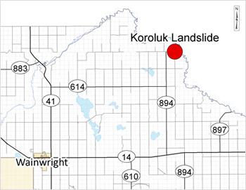
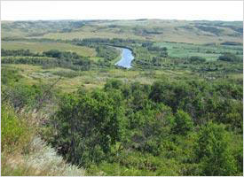
Koroluk Landslide is located 41 kms northeast of Wainwright. It is worth the trip to the site to take in the beauty and mystery of Mother Nature at work. The site is located at SW-3-47-4-W4, and can be reached by travelling North on Secondary Highway 894 until Township Road 470.
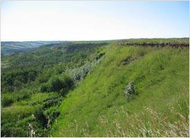
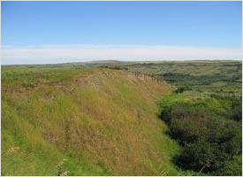
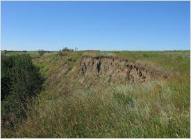
This slide is where the side of a hill collapsed and fell into a hole approximately 80 feet deep. The Koroluk Landslide extends over a one mile area, and a footpath leads you along the site to view and a kiosk at the entrance offers some background on and explanations for the slide.
Information from the Wainwright & District Chamber of Commerce:
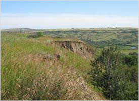
“Nature did some spectacular things in the Battle River Valley. A large chunk of soil of the farm of George Koroluk dropped almost straight down, leaving a cutbank over a thousand yards long and varying up to 80 feet deep. The chunk of soil remained largely intact with bush and trees still on it. The remainder of the hill to the far side of the fallen chunk also remains, with lesser downward movement. A general dropping of up to three or four feet appear on a long series of cracks extending far beyond the limits of the major land crop. Upheavals and cracks, as well as cutbank faces, also appear down toward the river bottom.
Mr. Koroluk has first noticed the land fault when it has dropped 7 feet on August 28th, 1974; two days later when he checked the spot, it had sunk over 70 feet. The sunken area is situated on the top of a hill with the Battle River about half a mile away. The top part of the hill has a crack in the earth extending over half a mile south; down towards the river there are cracks and faults in the earth’s surface from 6 inches to 7 feet wide. These fissures extend some 600 yards east, running parallel to the hillside north and south. There are more than 22 acres that are affected by the fissures and earth shifting with the one huge drop of more than two acres. The drop, which occurred in this case, was of unusual magnitude for this area and provided a spectacular example of movement for a valley the depth of the Battle River Valley.
Information from Dr. David Cruden of the department of Civil Engineering, University of Alberta, is that the soil movement was not the result of the wedge of earth dropping into some hole created by dissolving of some bed mineral or by the type of soil, which caused the homes to drift into a river in Quebec some years ago. Great pressure differentials occur as the result of the height of the overlay and when soils of the lower levels become plastic due to the unusual amounts of moisture, it is possible that they may move under the influence of these pressure differentials. This movement will result in some areas dropping and others rising. Mr. Gray, chief geologist for Ponderay Exploration Co. Ltd. Blamed the sink on soilifluction brought on by heavy precipitation. A lot of moisture gets into the lower part of the hill, made up of glacial deposits, mostly clay. Once the clay gets wet, it starts to slide, allowing the top section to sink.”